App showing your origin and destination
I had a comment this morning on one of the first posts I ever wrote on this blog. The post was about the Barcelona Metro iPhone app. And the comment was regarding a new rival iPhone app. I certainly don’t mind a bit of self-promotion in blog comments as long as it’s relevant. If I think readers of that post would find value in it then great. And in this instance I certainly didn’t need to worry.
The app in question that was so shamelessly promoted on this very blog was the Enllaç Barcelona Transportation iPhone App. From the website…
Enllaç is an application that helps you find the best route using Barcelona public transportation. All the principal modes of public transportation offered in Barcelona are covered: TMB, Bicing, Taxi, By Foot
By foot?! Yes. And it even tells you how many calories you will burn.
You can get just about anywhere by foot in Barcelona. So, in case you want to walk Enllaç gives you the shortest route and an estimate of the time it takes and the calories you’ll burn to get there. Remember, walking 30 minutes a day improves your quality of life!

Enllaç iPhone app showing overview of all 4 modes of transport
Well I never. An iPhone app that’s healthy too! And did I say it is also free. Yes free! Not one cent.
There is one word for this app. Slick. It is beautifully designed. Kind of what you’d expect as the app was developed by the guys at Aer Studio, an interaction design studio here in Barcelona. If it looked a bit crap they wouldn’t be doing themselves any favours would they. So, on to the review…
Let’s take it for a test drive…
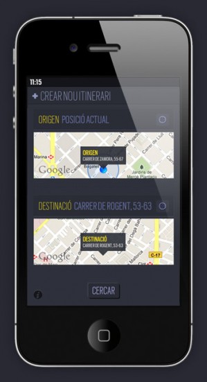
You open the app, and as you would expect it asks if it is allowed to use your location. It wouldn’t be much use if it couldn’t. You are then presented with a simple screen showing your Origin and Destination. At the moment they will be the same – your current location. Tap the destination address and you are able to enter where you would like to go. You can enter an address, a Metro stop, a park, or even the Cosmocaixa. Tap done and it will find the destination for you. You can tap the small map view to show your destination in full screen mode. And when in this mode you can drag the marker around in case you want to move it to somewhere more exact. Slick, slick, slick.
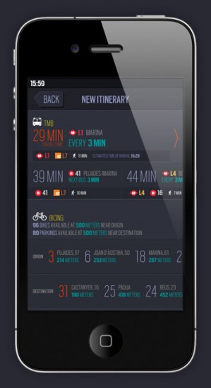
When you’re done playing around with the slick interface you can tap Search and the app will provide you with another slick interface detailing all 4 modes of transport.

Enllaç iPhone App showing TMB route details
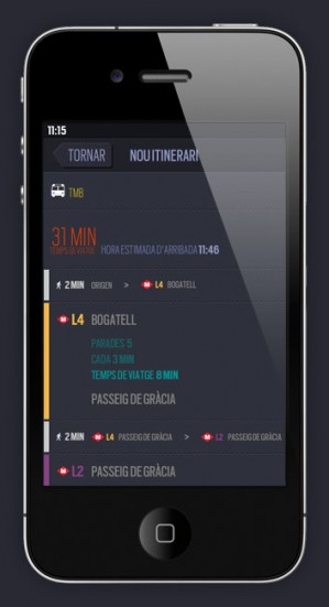
TMB: Tap the TMB section to see details of your route. Of course it will tell you the line to take, the station to go to and travel time. But also how many minutes it will take to walk to the station from where you are, the number of stops to your destination station, how often the trains run, and how far it is to walk from the station you get off at to your final destination.
If you fancy the bus it will show you all the options available to you with all possible details: how far to walk to the bus stop, when the next bus is, even bus and train combination journeys.
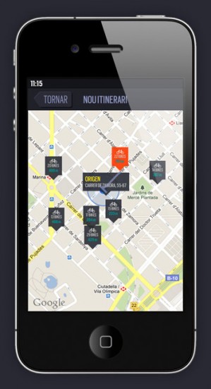
Bicing: For Bicing it tells me that there are “250 bikes available at 500 metres near origin”. And that there are “53 parkings available at 500 metres near destination”. Incredible. And you can scroll through the bike locations and decide which is the best one to go to. Tap the location to see it on a map.
Taxi: The taxi section shows the time it will take, estimated time of arrival and estimated fare. Tap the info to see the map and there’s even a Call a Cab button. This actually takes you to a Google search page for ‘taxi barcelona’ but that’s as good a place to start as any unless of course you just go out onto the street.
Walking: The walking section tells you the time it will take, the distance in kilometres and how many calories you will burn (that is, if you weigh 75kg and walk at 4km an hour). Click on the information and see the route on a map.

Enllaç iPhone app showing nearby Bicing stations
Slick.
I have to say the app did crash on me once while doing this review. But I was flicking about quite a lot so probably freaked it out a bit. The Bicing app crashes on me every time I use it, I have to actually close it down and start it again for it to stop crashing. The Barcelona Metro app I use currently is far more stable.
Also the taxi and walking routes didn’t seem to work (i.e. they both showed 0 minutes to destination) on one occasion. This seemed to be when I manually dragged the marker to a different location. It worked without fail when I typed in an address or location. Saying that I tried to recreate this error and failed so maybe just ignore me on this one. Although it did happen I assure you.
And I have to say I’m sure I could have come up with a better name – enllaç means ‘link’ in Catalan. It also happens to be a station on the Majorca rail network.
But all that aside, this app is so beautiful. And it shows all modes of transport in one app. I love it already. I can’t wait to use it properly when out and about instead of just sitting at my desk. And I assure you, if it doesn’t live up to its obvious beauty I will let you know.
You can find more information about the app here – Enllaç. There are versions of the site in English, Catalan and Spanish with a button so you can find it in the App Store. And if you follow Aer Studio on Twitter they provide tips in all languages on using the app. But it’s so intuitive you really don’t need them.
Be sure to let me know if you love it as much as I do.


What do you think? Leave a comment